Climate data engineers can actually use, delivered in 72 hours.
Get design-ready climate parameters without the data wrangling.
BuildForward™ transforms complex global climate models into the precise, site-specific design parameters your team needs for HVAC, structural, and civil applications.
Submit your project details to get started
Public climate datasets don’t directly translate to engineering decisions.
.png)
Model outputs, not observation-based
Extreme values underestimated
Wrong temporal resolution for design
Missing variables engineers actually need
Your team wastes days fighting with climate data. Meanwhile, the actual design work waits - and you're still not sure the data are defensible.

The BuildForward™ solution.
Engineering-grade climate data, delivered in 72 hours.
BuildForward™ is a rapid delivery service designed to answer one question: "What future do I need to design for?"

In 72 hours, we deliver a report with design-ready parameters for your project location.
What you get.

Understanding of how climate has already changed for your project location and where it's headed.
Clarity on how existing design parameters may shift over this century.
Local context on secondary hazards like hail, wildfire, subsidence, and flooding.
It’s about making better decisions today with the best available science.


Why BuildForward™
is different.

Built by climate scientists who've delivered data for infrastructure projects at global engineering firms.
Calibrated using 50,000+ weather stations, not generic model outputs.
Defensible in technical reviews: peer-reviewed methods, quantified uncertainty, full documentation.
How it works.
We deliver your report in 72 hours
Site-specific climate criteria derived from our network of 50,000+ weather stations, with documented methodology and data sources.
Use the numbers with confidence
Design values ready for your basis of design. Technical support from the experts available if reviewers have questions.
$4,500
Per location
PILOT OPPORTUNITY
Limited pilot slots may be available at reduced or no cost in exchange for structured feedback and a testimonial.
The price reflects
Expert-level climate science and targeted analysis.
Decision-grade outputs at a fraction of typical consulting costs.
Avoid multi-month engagements and design waste.
Ready to support multiple use cases.

Mechanical, Electrical & Plumbing
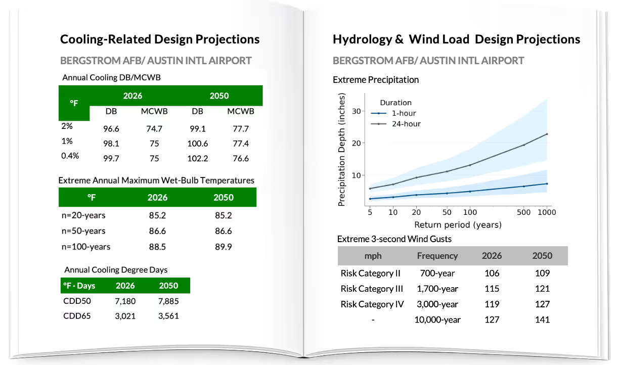
ASHRAE design temperatures and humidity extremes for HVAC sizing, energy modeling, and equipment selection.

Structural
Wind speed return periods for building codes, structural design, and roof loading calculations.

Hydrology & Hydraulics
Rainfall intensity-duration-frequency curves for stormwater design, drainage systems, and flood risk assessment.

Resilience & Infrastructure Planning
Climate-informed design values for long-lived infrastructure vulnerable to changing temperature and precipitation extremes.

Architects & Building Designers
Site-specific climate parameters for passive design strategies, building envelope performance, and energy efficiency.
Energy and Utility Professionals
Heating and cooling degree days, solar radiation, and temperature extremes for energy demand forecasting and grid planning.
The outcome.

Stop being the data team
Engineers engineer. We handle the climate science so your team can focus on design.

Quickly move projects forward
Design-ready parameters in 72 hours. Climate data stops being the bottleneck.

Defend your numbers with confidence
Peer-reviewed methods backed by 15+ years of climate risk experience. When reviewers ask questions, you have defensible answers.
Need custom analytics?
If your project requires custom climate analysis or independent review of existing data, we offer project-based consulting through our parent company Degree Day.
How is this different from downloading CMIP6 myself?

Public climate datasets (like CMIP6) provide raw model outputs, but not engineering design values.
To use them for infrastructure design, you'd need to:
- Download and process massive datasets (often terabytes)
- Select appropriate models and scenarios
- Calibrate outputs to local weather station observations
- Compute engineering-specific statistics (return periods, design temperatures, etc.)
Even with climate expertise, this takes weeks to months per location.
BuildForward delivers calibrated, design-ready values in 72 hours—already processed, validated, and documented for technical review.
Why should I trust your data?
Peer-reviewed methodology, 15+ years applying climate data, including at WSP, Arup, and NOAA. All projections calibrated to quality-controlled weather station observations.
Every report includes full methodology documentation, data provenance, and explicit uncertainty. When technical reviewers ask questions, you have defensible answers.
What is included in the report?
Each BuildForward report covers: Basic information on local climate and natural hazards - Context on your site's climate characteristics and relevant hazards.
Observed trends in local climate - Historical changes at your location based on weather station records.
Design values in current and future climates - Temperature extremes, wind speeds, precipitation intensities with specified return periods for baseline and future periods.
Methodology documentation - Data sources, bias correction approach, and statistical methods explained for technical review.
Data provenance - Complete documentation of climate models, scenarios, and weather stations used.
Reports are delivered as PDF, typically 50 pages.
Design values are delivered in Excel files. Technical support available if reviewers have questions.
What regions do you cover?
We cover all global regions. Our dataset includes over 50,000 weather stations worldwide.
If your project site isn't directly at a weather station, we use nearby stations to generate calibrated projections for your exact coordinates.
What if I have multiple sites?
Volume discounts are available. Request a quote when you submit project details and we will confirm exact pricing before starting work.